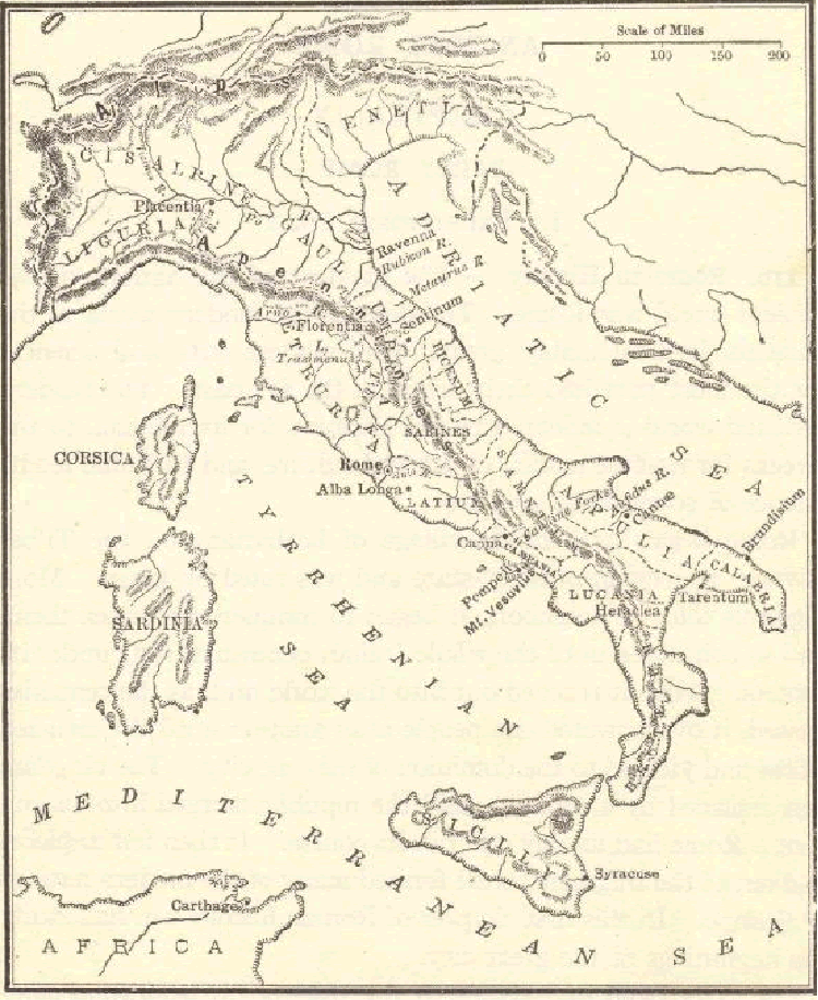
Ancient Rome: Map of the mountains, rivers, and divisions of Italy. Click here to enlarge the map.
The topography of Italy had a significant impact on ancient Rome in various ways, influencing its development, expansion, and daily life.
Geographic Advantages:
- Natural Defenses: Italy's geographical location provided natural defenses that helped protect Rome from external threats. The Italian Peninsula is surrounded by the Alps to the north, the Apennine Mountains running down its length, and the Mediterranean Sea to the west. These geographic features created natural barriers, making it more difficult for invading forces to approach Rome.
- Access to the Sea: Italy's western coastline along the Mediterranean Sea provided important access to maritime trade routes and allowed Rome to develop as a major naval power. It facilitated the movement of goods, troops, and communication with other parts of the Mediterranean world.
Agricultural Opportunities:
- Fertile Plains: Italy's low-lying coastal areas and plains, such as the Po Valley in the north and the Campania region in the south, were highly fertile and suitable for agriculture. These areas were known as the "breadbaskets" of Rome and provided essential food resources for the city and its growing population.
- River Systems: Italy's rivers, such as the Tiber, were crucial for transportation, irrigation, and agriculture. Rome was founded on the banks of the Tiber River, which provided a source of freshwater and a trade route to the sea.
Urban Planning:
- Hilltop Settlements: Rome itself was built on seven hills (Palatine, Capitoline, Quirinal, Viminal, Esquiline, Caelian, and Aventine), which offered strategic advantages for defense and provided a basis for the city's seven traditional districts.
- Aqueducts and Water Supply: The hilly terrain around Rome made it necessary to construct aqueducts to bring water from distant sources to the city. This engineering feat allowed Rome to have a reliable water supply for its growing population.
Expansion and Conquest:
- Strategic Location: Italy's central position in the Mediterranean made it a strategic point for expansion. The Romans used their central location as a base for military campaigns to conquer and control neighboring regions, ultimately creating a vast empire.
- Control of Key Passes: The Apennine Mountains, which traverse Italy, provided key passes that allowed Rome to control movement between different regions of the Italian Peninsula. The Roman road network was expanded to include these passes, enhancing Rome's control over the peninsula.
Trade and Commerce:
- Access to Trade Routes: Italy's location along the Mediterranean allowed Rome to access and control important trade routes that extended to North Africa, the Middle East, and other parts of Europe. This access facilitated the exchange of goods, culture, and ideas.
- Port Cities: Port cities such as Ostia, located at the mouth of the Tiber River, served as crucial gateways for imports and exports, further fueling Rome's economic prosperity.
The topography of Italy was both an advantage and a challenge for ancient Rome. While it provided natural defenses, fertile lands, and access to vital trade routes, it also necessitated engineering solutions for water supply and transportation. The Romans' ability to adapt to and exploit their environment played a significant role in their civilization's rise to prominence in the ancient world.
|


