| United States Time Zones Map |
| www.studenthandouts.com > Geography > Northern American Geography > U.S.A. Geography |
 |
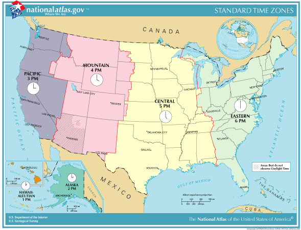
| Click here to print this map of the standard time zones in the United States. Image courtesy of the National Atlas. The United States spans multiple time zones, reflecting its vast geographic expanse from the Atlantic Ocean to the Pacific Ocean. There are six primary time zones in the continental U.S.: Eastern, Central, Mountain, Pacific, Alaska, and Hawaii-Aleutian. Eastern Time Zone (ET) covers the eastern part of the country, including major cities like New York, Washington, D.C., and Atlanta. Central Time Zone (CT) spans from the Great Lakes to the Gulf Coast, encompassing cities such as Chicago, Dallas, and New Orleans. Mountain Time Zone (MT) includes areas like Denver and Salt Lake City, while the Pacific Time Zone (PT) covers the westernmost states, including California, Oregon, and Washington. Alaska follows the Alaska Time Zone (AKT), which is one hour behind Pacific Time, reflecting the state's position further west. Hawaii and parts of the Aleutian Islands observe the Hawaii-Aleutian Time Zone (HAT), which is two hours behind Pacific Time and does not observe Daylight Saving Time. Daylight Saving Time (DST) is observed in most parts of the U.S., typically from the second Sunday in March to the first Sunday in November, except in Hawaii, most of Arizona, and U.S. territories like Puerto Rico and the Virgin Islands. The diverse time zones accommodate the country's wide geographical span, ensuring a standardized timekeeping system across different regions. |
 |
|---|
| www.studenthandouts.com > Geography > Northern American Geography > U.S.A. Geography |


