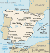
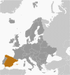
Spain, located on the Iberian Peninsula in southwestern Europe, boasts a diverse and varied geography that profoundly influences its climate, culture, and economy. Bordered by France and Andorra to the north, Portugal to the west, the Mediterranean Sea to the east and south, and the Atlantic Ocean to the northwest, Spain's landscape features a mix of mountains, plains, and coastline.
The Pyrenees Mountains form a natural border between Spain and France, stretching across the northern edge of the country. These mountains are characterized by rugged terrain and high peaks, such as Aneto, which rises to 3,404 meters (11,168 feet). The Cantabrian Mountains run along the northern coast, creating a dramatic backdrop to the lush green landscapes of the Basque Country and Asturias.
Central Spain is dominated by the Meseta Central, a high plateau that covers much of the country's interior. This region includes the capital city, Madrid, and is bordered by several mountain ranges, including the Sierra de Guadarrama and the Sierra de Gredos. The plateau's elevation contributes to its hot summers and cold winters, making its climate more extreme compared to coastal areas.
Spain's extensive coastline spans over 4,900 kilometers, with the Mediterranean Sea to the east and south and the Atlantic Ocean to the northwest. The Mediterranean coast, known for its warm climate and beautiful beaches, includes the Costa Brava, Costa del Sol, and the Balearic Islands. The Atlantic coast, including Galicia and the Basque Country, features rugged cliffs, sandy beaches, and a more temperate climate.
The Guadalquivir River, flowing through southern Spain, irrigates the fertile plains of Andalusia, supporting agriculture and viticulture. Spain's diverse geography, from the mountainous regions and central plateau to its extensive coastlines and river valleys, shapes its varied climates and rich cultural landscapes.
|


