Ireland Political Map |
| World Geography > Europe > Northern Europe > Ireland > Ireland Maps and Pictures |
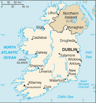 |
Political Map of the Island of Ireland: The southern portion, indicated in beige, is the independent Republic of Ireland. The capital city of the Republic is Dublin. Other major cities include Limerick, Shannon, Sligo, Lifford, Drogheda, Wicklow, Waterford, Cork, Killarney, and Galway. The northeastern portion of the island, indicated in brown, is known as Northern Ireland and is part of the United Kingdom. The capital city of Northern Ireland is Belfast. |
 |
|---|
 |


