| Philippines Political Map |
|---|
| www.studenthandouts.com ↣ Geography ↣ Asia ↣ SE Asia ↣ Philippines ↣ Philippines Images |
 |
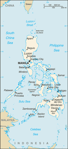
| Political map of the Philippine Islands. The Philippines is an archipelago (chain of islands) in southeast Asia. It is located north of Malaysia and Indonesia, and south of China, Japan, and Taiwan. The capital city of the Philippines is Manila. The Philippines has been an independent country since 1946. |
 |
 |  |  |  |  |  |
| www.studenthandouts.com ↣ Geography ↣ Asia ↣ SE Asia ↣ Philippines ↣ Philippines Images |


