

Norman Conquest Map Handout |
|---|
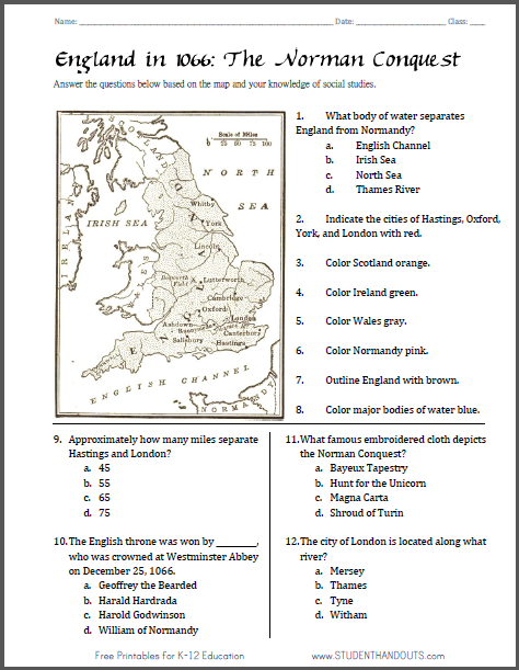
Free Printable Map Worksheet on England in 1066 for World History - European Middle Ages |
 |
    |
|---|
1. What body of water separates England from Normandy? a. English Channel b. Irish Sea c. North Sea d. Thames River 2. Indicate the cities of Hastings, Oxford, York, and London with red. 3. Color Scotland orange. 4. Color Ireland green. 5. Color Wales gray. 6. Color Normandy pink. 7. Outline England with brown. 8. Color major bodies of water blue. 9. Approximately how many miles separate Hastings and London? a. 45 b. 55 c. 65 d. 75 10.The English throne was won by __________, who was crowned at Westminster Abbey on December 25, 1066. a. Geoffrey the Bearded b. Harald Hardrada c. Harold Godwinson d. William of Normandy 11.What famous embroidered cloth depicts the Norman Conquest? a. Bayeux Tapestry b. Hunt for the Unicorn c. Magna Carta d. Shroud of Turin 12.The city of London is located along what river? a. Mersey b. Thames c. Tyne d. Witham |
|---|
| Middle Ages Books and Films | Middle Ages Outlines and Powerpoints |
| Middle Ages Maps and Pictures | Middle Ages Online Study Games |
| Middle Ages Miscellany | Middle Ages Printable Worksheets |
| www.studenthandouts.com > World History > Middle Ages > Middle Ages Worksheets |


